

 3 days ago
3
3 days ago
3

Behind China’s aircraft carriers lies the strategic depth of the Pacific; behind Türkiye’s, however, lie narrow seas that are becoming increasingly transparent.
*
One of the most consequential mistakes in debating the future of naval power is to treat the platforms operated by major powers as models that can be replicated independently of the geographic and strategic conditions in which they are employed. Such linear approaches overlook the most fundamental variable in maritime strategy: geography. The true value of a warship is determined not merely by the capabilities of the aircraft, missiles, or sensors it carries, but by where it will be positioned when war begins, the threats to which it will be exposed, how long it can survive in a contested environment, and whether it can continue to perform its assigned mission under combat conditions. The U.S.–Israel–Iran war has demonstrated this reality with striking clarity. Since February 28, 2026, the United States has been unable to deploy its naval forces into the Persian Gulf.
Türkiye’s geopolitical destiny in the twenty-first century will largely be determined in the Mediterranean. This reality requires Türkiye to pursue a strategic roadmap informed by both continental and maritime geopolitics. In important respects, Türkiye’s strategic predicament bears similarities to that of China. For this reason, the Chinese model offers an especially instructive point of comparison when considering the future structure of the Turkish Navy.
Within this framework, Türkiye must establish an appropriate balance between power projection and anti-access/area denial (A2/AD). Türkiye must possess power-projection platforms capable of supporting crisis management, gunboat and naval diplomacy, as well as humanitarian assistance and disaster-relief operations. At the same time, however, Turkish naval planning must fully account for the survivability of such platforms and the risks they would face during the opening hours of a high-intensity conflict. The principal lesson Türkiye should draw from China, therefore, is not simply that Beijing is building aircraft carriers. What deserves closer examination is where China intends to employ its carriers, for what strategic purposes, and within what broader A2/AD architecture. Behind China’s aircraft carriers lies the vast strategic depth of the Pacific Ocean. Behind a future Turkish aircraft carrier, by contrast, would lie the increasingly transparent and geographically confined waters of the Aegean and Eastern Mediterranean.
Power Projection, Anti-Access, and Area Denial
Two fundamental objectives in maritime strategy must be distinguished from one another. The first is power projection: the ability of a state to employ and sustain military power at considerable distances from its own shores. Aircraft carriers, amphibious assault ships such as TCG Anadolu, major surface combatants, and logistical support vessels are among the principal instruments of this function.
The second objective is to prevent an adversary from gaining access to a particular maritime area or from operating freely within it. The initial objective is to deny an adversary access to one’s coastline or maritime jurisdictional areas; if this cannot be achieved, the emphasis shifts toward denying the adversary freedom of action within the contested area. The concept commonly associated with sea denial in earlier naval-strategic literature, and increasingly conceptualized today through the framework of Anti-Access/Area Denial (A2/AD), represents the practical expression of this approach. The objective is not necessarily to establish command of the sea. In some circumstances, it is sufficient to deny the adversary command of the sea and prevent it from using the maritime domain freely for military purposes. This distinction is important because achieving strategic effects does not necessarily require the destruction of the opposing fleet. If the military, economic, and political costs of entering or operating within a particular maritime area can be raised beyond the benefits the adversary expects to derive from doing so, a strategic objective may already have been achieved. Iran’s current posture toward the U.S. Navy provides a contemporary example of the simultaneous application of both anti-access and area-denial measures.
The case of the Ottoman minelayer Nusret in 1915 provides a particularly striking historical illustration. On March 18, 1915, Ottoman naval and land forces were unable to prevent the Allied fleet from reaching the northern Aegean and the approaches to the Dardanelles. Once the Allied fleet had entered the contested battlespace, however, an effective area-denial system emerged through the combined employment of Nusret’s minefields and shore-based artillery. Before the Allied fleet could advance into the narrowest reaches of the Dardanelles, three battleships were sunk and three others were severely damaged, compelling the attacking force to withdraw.
The Russia–Ukraine war in the Black Sea offers a more recent example. Although Ukraine does not possess a conventional navy comparable to Russia’s Black Sea Fleet, it has substantially constrained the fleet’s freedom of maneuver through the combined employment of shore-based missiles, unmanned surface vessels, unmanned combat aerial vehicles, and other systems. Similarly, in the Red Sea, the missile and unmanned aerial vehicle threat posed by the Houthis—despite their far more limited resources—has demonstrated that even in a region where some of the world’s most powerful navies operate, asymmetric capabilities can significantly increase the costs and risks associated with maritime transportation.
China’s Great Advantage: An Ocean Lies Beyond the Island Chains
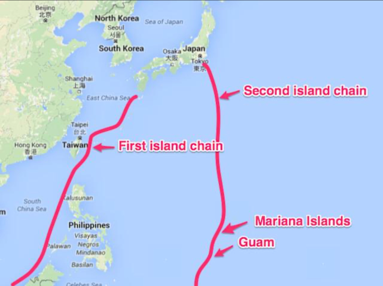
At first glance, China’s maritime geography appears to impose a major strategic disadvantage. China’s coastline is enclosed by the First Island Chain, extending through Japan, the Ryukyu Islands, Taiwan, and the Philippines. To reach the Pacific from the Yellow Sea, East China Sea, or South China Sea, the People’s Liberation Army Navy (PLAN) must penetrate this geographic barrier. The First Island Chain, however, is not an uninterrupted wall. From the perspective of a Taiwan-centered conflict, three areas are particularly important: the Miyako Strait, the Yonaguni–Taiwan passage, and the Luzon/Bashi channel system, all of which provide potential routes into the open Pacific. In wartime, of course, none of these passages would be inherently secure for China. Land-based anti-ship missiles, unmanned combat aerial vehicles, submarines, aircraft, and sensor networks operated by the United States, Japan, and the Philippines could place these routes under significant threat. The decisive strategic distinction, however, lies in what exists beyond these passages. Once China succeeds in moving a carrier strike group beyond the First Island Chain, it encounters the Second Island Chain.
Located farther east and extending across the Western Pacific, the Second Island Chain is a strategic belt centered primarily on the U.S. positions in Guam and the Northern Mariana Islands. Broadly defined, it extends from Japan’s Ogasawara (Bonin) Islands and Iwo Jima in the north, through Saipan and Tinian in the U.S. Commonwealth of the Northern Mariana Islands, to Guam, and farther south toward the Federated States of Micronesia and Palau. Its principal military center of gravity is the U.S. military infrastructure in Guam, particularly Andersen Air Force Base and Naval Base Guam. Both installations, however, lie within the reach of Chinese long-range strike capabilities.
Geographically, the First Island Chain forms a relatively confined maritime environment close to the Chinese mainland, characterized by narrow straits, restricted passages, and dense networks of sensors and weapons. The Second Island Chain, by contrast, extends across a vastly larger oceanic space. Consequently, the constraining power of the First Island Chain derives substantially from geography itself—the combination of narrow passages, proximity to land, and dense sensor and weapons networks. The military significance of the Second Island Chain depends less on geographic enclosure and more on the network of U.S. forward bases, air and naval forces, long-range strike capabilities, and intelligence, surveillance, and reconnaissance systems, particularly those centered on Guam and the Northern Mariana Islands.
Put differently, the First Island Chain constitutes a more formidable geographic barrier, whereas the Second Island Chain is better understood as a strategic belt whose military significance within the vast Pacific is largely derived from the network of U.S. bases and forces deployed across it. By analogy, the First Island Chain can be compared, in certain geographic respects, to the Aegean Sea, while the Second Island Chain may be compared to the broader Mediterranean. The critical difference, however, is that beyond both island chains lies the immense expanse of the Pacific Ocean. For China, gaining access to the open spaces of the Pacific is therefore considerably easier than it is for Türkiye to reach the Atlantic or Indian Ocean from its own maritime geography. The strategic depth China gains by penetrating the First and Second Island Chains is not limited to its ability to exploit the vast maneuver space of the Pacific.
The Solomon Islands and Kiribati stand out as two Pacific island states that could potentially provide China with forward logistical access in the future. The security agreement signed between China and the Solomon Islands in 2022 established a framework that could, under certain circumstances, facilitate Chinese naval visits and logistical support. The Solomon Islands’ position in the South Pacific is particularly significant because it could contribute to sustaining PLAN operations thousands of kilometers from China’s principal naval bases. Kiribati presents an even more expansive strategic geography. Its widely dispersed islands extend deep into the Central Pacific, creating long-term potential for port, airfield, and dual-use logistical infrastructure that could acquire considerable strategic significance for China. At present, China maintains no permanent naval base in either country comparable to its facility in Djibouti. Nevertheless, Beijing’s expanding political, economic, and security relationships with these states could create future options for replenishment, port access, and forward logistical support.
China’s ability to penetrate the island chains, therefore, represents more than an opportunity to move high-value naval assets into the strategic depth provided by the vast Pacific. It also creates the longer-term possibility of developing a distributed logistics network extending along a Solomon Islands–Kiribati axis, thereby supporting sustained Chinese naval operations at progressively greater distances from the mainland.
Türkiye’s Problem: The Ocean Does Not Begin Beyond the Aegean
Türkiye’s maritime geography is almost the inverse of China’s. The Aegean Sea is an exceptionally complex operational environment, fragmented by hundreds of islands, islets, and rocky outcrops. Under contemporary conditions, in which land-based radars, electro-optical systems, unmanned combat aerial vehicles (UCAVs), electronic intelligence assets, aircraft, anti-ship missiles, and submarines are increasingly integrated through networked systems, the Aegean’s effective operational space is shrinking even further. More importantly, leaving the Aegean does not give Türkiye access to the open ocean. Even after reaching the Eastern Mediterranean, the problem of strategic depth for a major surface combatant does not disappear. The Eastern Mediterranean, bounded by Crete, Cyprus, the Levantine coastline, and North Africa, is neither the Philippine Sea nor the Western Pacific. As satellite reconnaissance, synthetic aperture radar (SAR), unmanned aerial systems, maritime patrol aircraft, electronic intelligence capabilities, and long-range precision-strike systems continue to advance, the potential operating space in which a large platform can remain undetected and survivable becomes progressively smaller. For this reason, in twenty-first-century naval warfare, the physical size of a maritime theater and its effective military size are no longer equivalent. As sensor coverage and weapons engagement ranges expand, the Aegean and Eastern Mediterranean are effectively becoming smaller military operating environments.
.

Waters surrounding Turkiye
.
Türkiye has no geographic equivalent to the oceanic depth that China can reach after penetrating a maritime belt only a few hundred nautical miles in width. For a future 60,000-ton Turkish aircraft carrier to reach the Atlantic, it would have to traverse the entire Mediterranean and pass through the Strait of Gibraltar. To reach the Indian Ocean, it would have to transit the Eastern Mediterranean, the Suez Canal, the Red Sea, and the Bab el-Mandeb Strait. Once a high-intensity conflict has begun, it is self-evident that these distances and maritime chokepoints cannot be assessed according to the assumptions of peacetime navigation.
The Central Question in the Aircraft Carrier Debate: Survivability
Türkiye’s aircraft carrier project represents a highly significant technological threshold in terms of the country’s achievements in shipbuilding, defense-industrial capacity, and naval aviation. Moreover, should Türkiye need to establish a military and political presence in the Indian Ocean, Africa, or more distant areas of strategic interest in the future, such a platform could provide substantial power-projection capability. The question that must be addressed, therefore, is not “Can Türkiye build an aircraft carrier?” The more consequential question is: Can Türkiye ensure the survivability of such a platform in a high-intensity regional war? This question is particularly critical with regard to the opening days of a conflict.
It cannot be assumed that a future high-intensity conflict involving Türkiye would remain confined to a single front. A war could rapidly escalate horizontally, expanding across the air, maritime, space, cyber, and electromagnetic domains. In a multidirectional threat environment in the Eastern Mediterranean, major high-value surface assets could be subjected from the outset to intense intelligence, surveillance, and reconnaissance (ISR) coverage and long-range precision-strike pressure. Turkish defense planning must therefore take into account the possibility that the sensor networks, air forces, submarines, and long-range strike capabilities of Greece, The Greek Administration of the Southern Cyprus, Israel, as well as French and U.S. forces potentially operating in the region, could all be present within the same theater of operations. This does not imply that these states would necessarily execute a coordinated war plan against Türkiye. It does mean, however, that Turkish force planning must account for the most demanding and highest-intensity plausible scenario.
An aircraft carrier does not operate independently. It requires air-defense escorts, anti-submarine warfare assets, submarines, logistical support vessels, and airborne early-warning capabilities to protect it against threats from the air, surface, and subsurface domains. The result is therefore not a single ship requiring protection, but rather a large and expensive system of systems. More importantly, the loss of such a platform would represent far more than the loss of military capability and national wealth. The destruction of an exceptionally costly national platform, together with its embarked aircraft, could produce consequences disproportionate to its purely economic value, generating significant psychological, political, and reputational effects. Consequently, in the case of major high-value naval platforms, the strategic cost of losing a single unit can be extraordinarily high.
The First 72 Hours of War
One of the most important questions in future force planning, therefore, is which forces will be able to survive the first 24, 48, and 72 hours after the outbreak of hostilities and remain operationally effective. A platform may possess formidable firepower on paper. Yet if it can be continuously tracked by an adversary’s integrated network of satellites, radars, electronic intelligence systems, AI-enabled targeting capabilities, and long-range missiles, there is no assurance that this firepower will remain available for employment during the later phases of the conflict.
In this context, survivability is a prerequisite for firepower. A weapon that cannot be successfully targeted may ultimately prove more valuable than one possessing greater destructive power. Likewise, a platform that cannot be located is inherently more difficult to engage and destroy. Consequently, stealth, mobility, deception, surprise, and the ability to absorb losses should become fundamental design criteria in Türkiye’s future force structure.
An Anti-Access/Area-Denial Architecture for Türkiye
Submarines, unmanned surface vessels (USVs), unmanned underwater vehicles (UUVs), UAVs and UCAVs, mobile shore-based anti-ship missile batteries, long-range cruise and ballistic missiles, naval mines, electronic warfare systems, decoys, and widely distributed sensor networks should not be treated as independent capabilities. Rather, they should be conceived as interconnected components of a single, integrated anti-access/area-denial ecosystem. Instead of concentrating firepower in a small number of exceptionally expensive platforms, Türkiye should prioritize distributing combat power across hundreds of mobile, concealable, and geographically dispersed nodes. Such an approach is particularly well suited to congested and high-intensity littoral environments such as the Aegean and Eastern Mediterranean.
On land, mobile missile batteries should be protected through a combination of underground facilities, mountain shelters, hardened bunkers, and tunnel networks, drawing lessons from the approach developed by Iran. These should be complemented by decoy positions and highly mobile systems that continuously relocate in order to complicate adversary targeting. The objective is not merely to protect individual weapons systems. It is also to dilute and overload the adversary’s intelligence, surveillance, reconnaissance, and targeting capacity across the largest possible number of potential targets, while making it increasingly difficult to distinguish genuine military assets from decoys. In this way, survivability becomes a function not only of physical protection, but also of uncertainty, dispersion, mobility, and deception.
Unmanned surface and underwater vehicles can perform a wide range of missions, including intelligence, surveillance, and reconnaissance; electronic warfare; mine warfare; deception; and, where operationally appropriate, missile carriage. One of their principal advantages is that their loss does not generate the same strategic, political, or psychological consequences associated with the destruction of large, manned platforms. This makes them particularly valuable within a force structure designed around dispersion, redundancy, resilience, and acceptable levels of attrition.
The Real Lesson Türkiye Should Draw from China
It is precisely at this point that the Chinese model becomes particularly relevant. If China’s naval modernization is viewed solely through the lens of its new aircraft carrier, Fujian, the resulting conclusions will be misleading. At the same time that China is developing carrier aviation, it is also constructing a multilayered anti-access/area-denial architecture designed to make the approach of U.S. aircraft carriers and other high-value naval assets toward the Chinese coastline and critical operational areas increasingly hazardous. Long-range ballistic and cruise missiles, hypersonic weapons, submarines, bombers, unmanned systems, electronic warfare capabilities, and space-based reconnaissance and targeting systems all form integral components of this architecture.
In China’s approach to countering distributed U.S. naval forces, the aircraft carrier itself need not necessarily be the first target. A critical objective is to deplete the defensive missile inventories of the escorting warships and progressively degrade the carrier strike group’s defensive network. Once those defenses have been stressed or penetrated, successive attack layers involving inexpensive decoys, low-altitude cruise missiles, and hypersonic weapons can be brought to bear. What ultimately matters, therefore, is not the performance of any single missile but the interaction of multiple capabilities within a broader system-of-systems contest.
Submarines and Long-Range Missiles
The submarine remains one of the last major military platforms capable of exploiting concealment in an increasingly transparent battlespace. The approximate operating area of a land-based missile battery may eventually be identified. A large surface combatant can be tracked through space- and air-based intelligence, surveillance, and reconnaissance systems. The coordinates of major air bases are known. The position of a quiet submarine, however, may remain uncertain. Combining submarine stealth with long-range anti-ship and land-attack missiles can therefore generate a powerful strategic effect. China’s efforts to develop a new generation of submarine-launched hypersonic anti-ship missiles are particularly significant in this regard and deserve close examination by Turkish defense planners.
Within this framework, technologies developed through Roketsan’s Tayfun program—including solid-propellant propulsion, guidance and control, terminal maneuverability, and long-range precision-strike capabilities—could provide a technological foundation from which maritime applications might eventually be developed. For existing submarines, one intermediate step could involve the development of encapsulated, torpedo-tube-launched long-range weapons derived from the Atmaca or Gezgin families. At a later stage, the MİLDEN design could incorporate architectural solutions capable of accommodating larger missile systems. The ability of Turkish submarines to threaten high-value maritime and land targets hundreds of kilometers away without revealing their positions would begin to influence an adversary’s operational planning even in peacetime. The commander of an aircraft carrier or major surface action group would have to account for the possibility of operating within the weapons engagement envelope of Turkish submarines without knowing where those submarines were located. This is where the true deterrent effect of anti-access becomes evident: the adversary is compelled to alter its behavior not because it knows where the threat is, but precisely because it does not.
An Attritable Force
One of the increasingly important concepts in future warfare will be the employment of systems whose loss can be operationally absorbed. This does not mean producing cheap or militarily insignificant weapons. Rather, it means reducing the strategic vulnerability created by concentrating combat power in a small number of exceptionally expensive platforms.
The loss of an aircraft carrier could become a national trauma. The loss of an unmanned maritime system, by contrast, can be incorporated into operational planning. Hundreds of unmanned systems may be lost while the remaining units continue to perform their missions. Such an approach can force an adversary to expend sophisticated sensors, interceptors, and other costly defensive resources against substantially less expensive targets, while increasing the probability that the principal strike assets will survive and remain operational.
Türkiye should therefore reconsider the balance between manned and unmanned systems within its future force structure. Equipping unmanned surface and underwater vehicles with missile, electronic warfare, intelligence, surveillance and reconnaissance, mine-warfare, and deception capabilities would be particularly well suited to the geographic and operational characteristics of Türkiye’s confined maritime environment.
Does This Mean Abandoning Major Platforms?
This argument should not be interpreted to mean that Türkiye should refrain from building major naval platforms altogether. Türkiye is not solely an Aegean and Eastern Mediterranean power. Its economic and strategic interests may increasingly extend into the Red Sea, the Horn of Africa, the Indian Ocean, and potentially more distant maritime theaters. Under such circumstances, aircraft carriers and other major power-projection platforms could acquire considerable strategic utility. The geography of their forward deployment, however, should be reconsidered. Developing long-term naval logistics infrastructure in friendly countries such as Somalia, which offers direct access to the Indian Ocean, could allow major Turkish naval platforms to operate much closer to the open ocean rather than attempting, after the onset of a crisis or war, to traverse the entire Eastern Mediterranean, the Suez Canal, the Red Sea, and the Bab el-Mandeb Strait.
The strategic significance of such an approach is considerable. The survivability problem of a major power-projection platform cannot be solved solely through its organic air and missile defenses. Geographic positioning is itself a form of defense. In this context, particular attention should be given to the potential strategic interaction between a future Turkish naval presence in Libya and Türkiye’s expanding military presence in Somalia and the Red Sea region. Together, these positions could enable Türkiye to generate power-projection capabilities simultaneously across the Mediterranean and Red Sea approaches, while reducing its dependence on moving major naval assets through multiple contested chokepoints after the outbreak of a crisis.
Conclusion: Geography Must Shape Force Structure
This is the most important lesson to emerge from the comparison between China and Türkiye. Within the First Island Chain, China operates under significant geographic constraints. Yet once it penetrates critical gateways such as the Miyako Strait or the Luzon/Bashi channel system, it gains access to the immense strategic depth of the Philippine Sea and the Western Pacific. Beyond the Second Island Chain, that oceanic depth expands even further. Türkiye, by contrast, gains no comparable advantage once it moves beyond the Aegean. The Eastern Mediterranean remains a geographically constrained operational environment within the reach of land-based airpower, missiles, submarines, and increasingly sophisticated intelligence, surveillance, and reconnaissance systems. To reach the Atlantic, Turkish naval forces must traverse the Mediterranean and pass through the Strait of Gibraltar; to reach the Indian Ocean, they must negotiate a long maritime route extending through the Eastern Mediterranean, the Suez Canal, the Red Sea, and ultimately the Bab el-Mandeb Strait. It is therefore strategically misleading to compare Chinese and Turkish requirements for aircraft carriers solely in terms of economic capacity, fleet size, or national prestige. Behind China’s aircraft carriers lies the strategic depth of the Pacific Ocean. Behind a Turkish aircraft carrier lie increasingly transparent and confined seas.
The lesson to be drawn from China, therefore, is that Beijing is simultaneously developing two complementary capabilities: aircraft carriers designed to project power into distant maritime theaters, backed by the strategic depth of the Pacific Ocean; and an extensive anti-access/area-denial architecture designed to prevent an adversary’s high-value naval assets from approaching China’s coastline and critical operational areas. Türkiye must likewise shape its future force structure according to the realities of its own geography. Submarines; long-range and, eventually, hypersonic anti-ship weapons; armed unmanned surface and underwater vehicles; mobile shore-based missile batteries; naval mines; electronic warfare capabilities; hardened and underground missile infrastructure; and distributed sensor networks should constitute the foundations of this architecture.
In the high-intensity warfare of the future, superiority will not necessarily belong to the state possessing the largest, most expensive, or most imposing platforms. True superiority will belong to the force that, after absorbing the first blow, can still see, still communicate, still maneuver, and still fire.
.
*
Click the share button below to email/forward this article. Follow us on Instagram and X and subscribe to our Telegram Channel. Feel free to repost Global Research articles with proper attribution.
This article was originally published on Mavi Vatan.
Ret Admiral Cem Gürdeniz, Writer, Geopolitical Expert, Theorist and creator of the Turkish Bluehomeland (Mavi Vatan) doctrine. He served as the Chief of Strategy Department and then the head of Plans and Policy Division in Turkish Naval Forces Headquarters. As his combat duties, he has served as the commander of Amphibious Ships Group and Mine Fleet between 2007 and 2009. He retired in 2012. He established Hamit Naci Blue Homeland Foundation in 2021. He has published numerous books on geopolitics, maritime strategy, maritime history and maritime culture. He is also a honorary member of ATASAM.
He is a Research Associate of the Centre for Research on Globalization (CRG).
Featured image is from the author
Global Research is a reader-funded media. We do not accept any funding from corporations or governments. Help us stay afloat. Click the image below to make a one-time or recurring donation.

















.png)






.jpg)



 English (US) ·
  French (CA) ·